World Leader in Professional UAV Autopilots
Home
About Us
About MicroPilot
Our History
Our Facilities
Our People
Contact us
Products
Circuit Board Autopilots
Integrated Autopilots
3x Autopilots
Xtender
XTENDER
mp
XTENDER
VALIDATE
trueHWIL
2
HORIZON
mp
Developers Packages
Accessories
Services
Training & Integration
XTENDER Training
Custom Development
Flight Facility
Clients
Multirotor
Fixed wing
Helicopter
Other
News
Readings
Articles
FAQs
Manuals
White Papers
Infographics
Blog
Careers
Partners
Store
Safety First
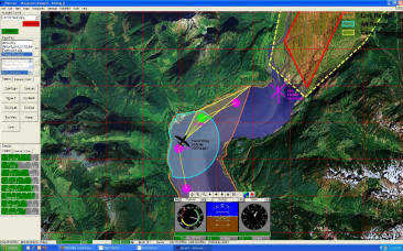
MicroPilot’s HORIZON
mp
Ground Control Station Software has the features you need to operate safe, repeatable missions.
Map annotation and user definable no-fly zones let your UAV operators add the information they need to their maps.
Digital Terrain Data Ready: take advantage of Digital Elevation to simplify operation.
Safe Terrain Range Displayed on Map so your UAV operators can tell where to fly.
Safe Comm. Range and Safe Terrain range on Map reduces UAV operator workload.
Terrain look helps prevents terrain conflicts.
No-Fly Zone look ahead warns users before they violate a no-fly zone.
Comm Link out of range look ahead helps prevent loss of link.
Integrated software in the loop simulator provides a training mode: available at the push of a button
Automatic safe return home altitude maximizes your ability to recover your UAV in the event of a loss of communications.
Previous
|
Next
Safety First
Operator Oriented
GCS Aware
Multi-UAV Support
Integrator Friendly
Advanced Simulation
Video Friendly
Video Friendly
Advance Joystick Support
Error Monitor
Sensor Monitor
Launch & Recovery Monitor
Checklists
Waypoint Import
Waypoint Grid Generator
NMEA Output