World Leader in Professional UAV Autopilots
Home
About Us
About MicroPilot
Our History
Our Facilities
Our People
Contact us
Products
Circuit Board Autopilots
Integrated Autopilots
3x Autopilots
Xtender
XTENDER
mp
XTENDER
VALIDATE
trueHWIL
2
HORIZON
mp
Developers Packages
Accessories
Services
Training & Integration
XTENDER Training
Custom Development
Flight Facility
Clients
Multirotor
Fixed wing
Helicopter
Other
News
Readings
Articles
FAQs
Manuals
White Papers
Infographics
Blog
Careers
Partners
Store
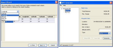
Waypoint Import
Interfacing with other systems is a fact of life. The ability to import waypoints and other data from these systems saves time and improves accuracy.
Generate Waypoints from a CSV or ESRI shape file so you can import flight plans from other GIS systems.
Accepts Lat/Lon, UTM or MGRS for maximum flexibility.
Import Altitudes for 3D flight profiles
Set field values based on data in the imported file.
Previous
|
Next
Safety First
Operator Oriented
GCS Aware
Multi-UAV Support
Integrator Friendly
Advanced Simulation
Video Friendly
Video Friendly
Advance Joystick Support
Error Monitor
Sensor Monitor
Launch & Recovery Monitor
Checklists
Waypoint Import
Waypoint Grid Generator
NMEA Output