|
|
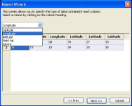
Waypoint Import
|
|
Interfacing with other
systems is a fact of life. The ability to import
waypoints and other data from these systems saves time
and improves accuracy.
|
|
|
|
- Generate Waypoints from a CSV or ESRI
shape file so you can import flight plans
from other GIS systems.
- Accepts Lat/Lon, UTM or MGRS for maximum
flexibility.
- Import Altitudes for 3D flight profiles
- Set field values based on data in the
imported file.
|
|
| |
|
|