|
|
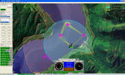
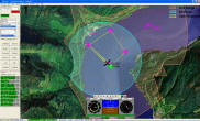
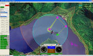
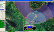
GCS Aware
|
|
HORIZONmp tracks its
location as well as the UAVs. Many GCS location features
help maintain operator situational awareness and
geographical awareness.
|
|
|
|
- Moveable GCS location plotted on map
based on UAV launch location or GCS GPS
receiver.
- Map Rotates automatically based on GCS
compass helps UAV operators maintain spatial
awareness.
- Map Rotates automatically based on GCS
heading in moving vehicles.
- Simulated GCS movement allows a training
mode
- Antennae pointing simplifies the use
of directional antennas.
|
|
| |
|
|