|
|
Safety First
|
|
MicroPilot’s HORIZONmp
Ground Control Station Software has the features you
need to operate safe, repeatable missions.
|
|
|
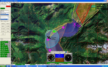
- Map annotation and user definable no-fly
zones let your UAV operators add the
information they need to their maps.
- Digital Terrain Data Ready: take
advantage of Digital Elevation to simplify
operation.
- Safe Terrain Range Displayed on Map so
your UAV operators can tell where to fly.
- Safe Comm. Range and Safe Terrain range on Map reduces UAV operator
workload.
- Terrain look helps prevents terrain
conflicts.
- No-Fly Zone look ahead warns users
before they violate a no-fly zone.
- Comm Link out of range look ahead helps
prevent loss of link.
- Integrated software in the loop
simulator provides a training mode:
available at the push of a button
- Automatic safe return home altitude
maximizes your ability to recover your UAV
in the event of a loss of communications..
|
|
| |
|
|